31 May 1991

1991 - Darjeeling - Gangtok - Nathu La - Kalimgpong Trip.

1991 - Darjeeling  - Gangtok - Nathu La – Kalingpong.

THIS BLOG WAS WRITTEN BETWEEN 19 and 31May  2021 

Irrespective of the date when the map was made and the blog published, It has been published backdated, to maintain historical sequence.

These blogs are written as much to record our travels and places we have seen all those years in the past, as they are to present a photographic record of the growth of Ajeet and Anuj through those early years.

 Darjeeling  - Gangtok - Nathu La - Kalimgpong Trip.


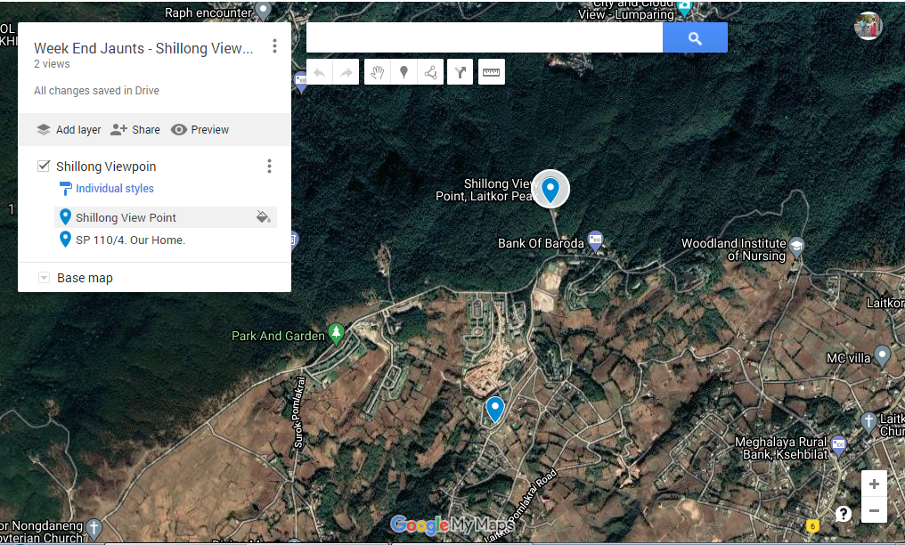
This is a screenshot of our Darjeeling - Gangtok - Nathu La - Kalimgpong Trip. This Screenshot is just to give you an overall picture of the routes followed, places where we stayed, and the tourists' attractions we visited. 

But these details can not be accessed here.
Full details and description about routes places stayed, and the information/writes up about tourists attractions visited by us, can be accessed in "interactive" google map. 
For an interactive map GO HERE. 
For the album with photos of Darjeeling  - Gangtok - Nathu La – Kalingpong trip Go Here.
For main 10 ALBUM MAY 1990 - OCT 1992.which contains photos of the above trip Go Here.
PQ 55/4. Our home.
Background.
It was pure luck that when we were returning from Indore trip in 1990, we had run into Col Suresh Gadre at the Officer’s Mess Fort Williams. He was then Chief Works Engineer at Siliguri. On hearing our desire to see as many states and places in the East during our Shillong posting, he told us that as CWE his area of responsibility included West Bengal and  Sikkim. He would help us in visiting Darjeeling, Gangtok, Nathu La Pass and Kalimpong. All these places were worth seeing for their natural beauty. We of course knew it and were keen to see them.
After returning to Shillong I had kept in touch with him. When we finally decided to undertake the trip we informed him when we would arrive in Siliguri.
Now the catch here is that there was no date stamp on any of the photos and none of us remembers either the dates or the month of the visit. The only Available clue is that in the last of the photos taken at Kalimgpong/ Siliguri we are wishing Priti (Mummy) Happy Birthday, So, on 7th May 1991 we were in Kalimpong/Siliguri.
This way, May as the month was decided for this blog. Photo of Siliguri mess has a noting       " 5 FOD Mess, 30 April 1991" So we were in Siliguri on 30 April. However, all otherdetails, dates remain elusive and no dates have been recorded for any other places.
 Shillong to Siliguri via Guwahati.
First a road journey from Shillong to Guwahati. Thereafter we travelled by train from Guwahati to Siliguri.
No photos and no details are available.
Officers Mess, Siliguri.
 Not many memories.
It can be safely assumed that we must have called on Suresh Gadre and at least had one meal with them.
He briefed us that he has detailed a jeep along with the driver. The driver was briefed about where all to take us. He was also told about our accommodation at various places and other details.
Suresh had made arrangements for our stay in the officer’s mess.  Unfortunately, most of the photos do not have map locations. Given here is the assumed location of the mess. The reason for locating it there is that it is next to CWE’s office and near some married quarters.  The driver picked us up the next morning. 
Our trip to Darjeeling etc had commenced.......
Officers Mess, Siliguri – Darjeeling Road Route.
The driver reported well in time. We had already collected our packed breakfast and were ready to go.
During the journey from Siliguri to Darjeeling you climbed almost 6300 Feet that being the difference between the height of Siliguri (392 feet AMSL)  and Darjeeling(6700 feet AMSL).
At many places, the climb is quite steep and there are hundreds of hairpin bend in the road. Luckily by this time Ajeet’s road sickness was over. We never found precisely when and how he overcame that malaise.
The route is quite picturesque. One is captivated by the beauty of nature. Steep hills on one side and deep gorges on the other side of the road.
Added to the natural beauty of the route is the presence of a rail line of toy train from Siliguri to Darjeeling which runs along the road for most of the distance.
Almost halfway to Darjeeling, the Railway line almost traverses through a circle. The road runs right next to this point. This place when we had travelled way back in 1991, was known as “Ghoom-Loop” Due to its proximity to the village and Monastery of that name. It is said that people from the train get down at the beginning of the loop, walk across and again boarded the train on the other side of the loop. At that time the area within the loop was a saucer-like depression. It was a barren grassy patch with a couple of odd trees and wild growth of shrubs and bushes. 
Today in 2021, Satellite view of the google map shows it is now called “Batasia Loop.”.  The place is totally transformed and has been made a major tourist attraction with a garden, War memorial etc. The link for the write up about  Batasia Loop by Darjeeling tourism is @ https://www.darjeeling-tourism.com/darj_000017.htm
Photos taken during the road trip are given here as well as uploaded on the map at the photo location.  

Mall Road/ Chourasta, Darjeeling.
Went to Chorasta( four roads) at the end of the mall road.
Chourasta and Mall are located at the heart of Darjeeling. It is the main tourist spot and commercial hub of Darjeeling. Most of the vintage shopping places and hotel are located around this place. 
It is the place where the tourist and locals gather to enjoy the beauty and bask in the sun. Pass time looking at the people going about their business and generally pass time in a congenial atmosphere.
On a clear day from various vantage points around this place, one can have a magnificent view of Kanchanjunga in all its glory. Priti and I had visited Darjeeling at least three times earlier. Unfortunately, we never had a look at Kanchanjanga as on our every visit there were too many clouds around and the peak was hidden behind the clouds. Our luck did not change even this time. Poor Ajeet and Anuj also missed out on the beautiful view.
Collage of photos here and on the map.

The link for the write up about  Mall Road and Chowrasta by Darjeeling tourism is @ https://www.darjeeling-tourism.com/darj_000013.htm
Went around sightseeing, maybe for a couple of hours and then set a course for Gangtok.
Darjeeling - Gangtok Road Route.
After all these years too many details of the journey are forgotten. However, judging from the terrain it must have been a thrilling and adventuresome journey.
Apparently, no photos were taken en route.
 Gangtok.
A Mess, 17 MT Div.
We had Stayed in A mess of 17 Mountain Division. I had no idea of its location. Then I remembered that Ravi was posted to Gangtok while we were in Shillong. So I asked him if he remembered the location. He replied to inform that while he was there in 1993 A Mess was located near the present location of Black Cat Institute. Accordingly, I have put the location of the mess near BCI. From looking at the photos one can easily imagine how fantastic was the panoramic view of Gangtok and the valleys and mountains from the mess. 
Do not remember the duration of our stay. 
we saw Rumtek Monastery and Orchid Garden in Gangtok. 

 Rumtek Monastery.
My memory is that the statues and the paintings had very vivid and brilliant colours. We were told that no synthetic or modern paints were used Only vegetable paints made by the monks were used. Which, looking at the colours themselves I felt was a fantastic achievement.
Following description based on wiki and incredible India web sites.
Rumtek Monastery also called the Dharma Chakra Centre,  is located around 24 km from Gangtok.
It is the largest monastery in Sikkim and reflects the best of Tibetan architecture. 
It is located in a very picturesque location with flowing streams, the mountain behind and snowclad ranges in front and a river below.
The prayer hall has splendid murals, statues and 'Tangkhas'. 

Flower Show Center.
Do not remember much about this place. Looking at the photos there must have been plenty of orchard varieties and other flowers on display. Write up on this from Sikkim and Darjeeling tourism website is given as captions in photos taken at flower Show centre.
Today in the photos of these websites it is looking fabulous. Many of the facilities like a paved pathway, fountain etc may not have been there in 1991 but natural beauty must have been always there.
Gangtok - Nathu La Road Route.
The memory so far as this trip, Darjeeling, Gangtok, Nathu La and Kalimgpong trip is concerned is mostly blank. 
Do not remember the dates, the duration, the location of places where we stayed, how much was our stay at each place. Sufficient details about places we saw to describe them from memory are also missing. 
To put it bluntly, do not remember anything at all.
If it was not for the photos and sketchy captions written in the album when the trip was fresh in mind, I would not have been able to write anything at all. This one sentence "In 1991 we went on a trip to Darjeeling, Gangtok, Nathu La and Kalimgpong", would have said it all. 
Having said all that, some incidents during the road journey to Nathu La and at Nathu La itself are etched so deeply that I am not likely to forget them ever! 
Here are few such memories. 
Tigers Path
On the road, there is a Brick and cement road sign stating Tigers Path. By the time we had reached this place, we were already climbing for quite a while. At places, the climb was quite steep. At places hairpin bend one after the other. On one side there were steep mountains and on the other side deep valleys. The valleys were all covered in clouds. Clouds were coming down from the higher mountains and settling down in the lower levels of the valleys. In fact, at many places, we were driving through thin layers of clouds. While taking a break our driver told us that on this route if the clouds increase become thicker and settle down on the road reducing visibility to such a degree that one had to either turn back or wait for the clouds to lift up. In fact, he told us that if such a thing had to happen we would have to cancel the further journey and return to Gangtok. Fortunately, the clouds did not worsen and we could complete the trip.
 Changgu Lake - Tsongmo Lake - Tsomgo Lake, 
Even before we had reached the Tigers Path sign, we were seeing snow deposits along the road and the surrounding hills. The thickness of the snow deposits kept increasing as we went further and higher towards Nathu La. Few kilometres after the Tigers Path sign reached Changdu lake. It is a glacial lake, some 40 kilometres (25 mi) from the capital Gangtok. It is located at an elevation of 3,753 m (12,313 ft), 
 Lake was not frozen. However all around the lake, ground and hillside were covered with snow. At this place, it was not an unbroken blanket as patches of barren earth were interspersed with snow-covered ground.
 The water was dull grey with low clouds. Its mirror-like surface without even a ripple on its surface as there was no wind at all. There was death-like silence all around. Without any greenery and signs of any type of life along the lakeshore. The scene appeared totally barren desolate. In a strange way, it still appeared quite majestic and had a beauty of its own. 
This was a far different scene from what has been described in Wikipedia about the lake. Excerpts are given below.
The lake is the venue for the Guru Purnima festival which is also the Raksha Bandhan festival when the faith healers are known as Jhakris of Sikkim assemble at the lake area to derive benefits from the healing qualities of the lake waters.
After the winter season ends in the middle of May, the periphery of the lake has scenic blooms of flower species of rhododendrons (the state tree of Sikkim), primulas, blue and yellow poppies, irises and so forth. Also seen in the precincts of the lake are several species of birds including Brahminy ducks. Wildlife seen includes the red panda.
Tourist attractions at the lake site include joy rides on decorated yaks and mules where kiosks offer a variety of food and drinks. There is also a small Shiva temple on the bank of the lake.
 More details at https://en.wikipedia.org/wiki/Lake_Tsomgo
Encounter at the bunker. The road became Steeper and the number of hairpin bend also increased. Came across a bunker. When we went to have a look at it met a young Sardar ji 2nd lieutenant. He was posted there and was staying in the bunker. It was a hard and lonely life for a young fauji. Mummy had carried some laddus for us to eat in case Ajjet, Anuj felt hungry. She gave a couple of them to that young lonely boy. He was overjoyed and almost ecstatic at getting something sweet and cooked at home. we can never forget the joyful expression on that young officer's face.
Nathu La. 
 Eventually, the climb eased off. and we had reached a point where the road was almost level with a hint of a gentle climb towards Nathu La. The height of Nathuls pass is 14149 Feet AMSL. Even in May, there was a thick blanket of snow and all the hill ranges were totally covered with snow. One could imagine how tough life would be in the hick of winters. 
The road surface had become very slippery. Our jeep slipped and skidded badly. It was very scary as the danger of going off the road was very real. It was a feeling we would never forget. Eventually, we were just crawling along even at that slow speed the driver had difficulty in controlling the slip and skid. When we came in the sight of Nathula which may have been just about a km away we left the slipping and skidding jeep behind and started walking. At places, we had to traverse through the snow and our shoes became wet and soggy. Pant bottoms were also wet. All that discomfort could not dampen our spirits which were buoyed by the beautiful awesome sight of the snow-covered mountain ranges as far as we could see. 
Gol Ghar. 
We were led to a round gazebo sort of structure with a roof of galvanised iron sheets and large glass windows all around to give a good all-around lookout of 360 degrees. This was called Gol Ghar due to its round shape. It was located almost on the border and China was less than a stone's throw away! Mountain ranges on the Chinese side were given names by our jawans based on the shape of the mountain range against the horizon. A mountain looking like the hump of a camel was called Camelhome,. There was also a Rabbit mountain and some more. This way when the camel mountain name was mentioned everyone knew where to look and which place was being referred to. 
After spending some time at Gol Ghar started back to go back to Gangtok.
After a good night's sleep, the next morning set course for Kalimpong.
Gangtok - Kalimpong Road Route. 
Started for Kalimpong. for almost half the distance it was the same route we had come from Darjeeling.
The first break was at the Rangpo Police check post. The arched gate declaring that it was the border between Sikkim and West Bengal was of typical Sikkim architecture and looked good so took a photo./
Short of Chitery, Teesta Forest we turned left for Kalimpong. 
Later as the road was running very close to Teesta River had couple of breaks before finally reaching Kalimpong. /There is no record of where we stayed. As Suresh who was CWE, I felt that the most probable place would be either in the officer's mess of some army unit or MES Inspection Bungalow. I have opted for MES IB as the place we stayed in Kalimpong.
Durpin Monastery, kalimpong.
Went to see Dupin Monastery. The statues, the draperies, the tapestries etc were similar to what we had seen in Rumtek Monastery. This may give one a wrong impression that "you have seen one monastery, you have seen them all".
Nothing could be far from the truth.  
The statues are so beautiful, the tapestries so amazing. The colours of the tapestries so vibrant and vivid, the designs so good. The weaves and designs of draperies so beautiful that no matter how many times earlier you may have seen them, at every fresh look they look as beautiful as ever. One can never get enough of their beauty, no matter how many times you have seen them. And so it was at Durpin Monastery. Enjoyed the visit thoroughly.
 Following courtesy Lonely Planet.
Kalimpong’s largest monastery, formally known as Zangtok Pelri Phodang, sits atop panoramic Durpin Hill (1372m) and was consecrated by the Dalai Lama in 1976. There are impressive murals in the main prayer room downstairs, presided over by Padmasambhava (the Indian sage credited with spreading Buddhism in Tibet in the 8th century), interesting 3D mandalas (visual meditational aids) on the 2nd floor, and stunning Khangchendzonga views from the terrace. Prayers are held at 6am and 3pm.
The monastery is about 5km south of the town centre, most easily reached by taxi (one-way ₹200). It's a pleasant mostly downhill walk back to town, passing the army golf course and canteen. You can stop for a tea at the 1930s English-country-style Morgan House, now a state-government-run hotel.
BN Pradhan Cactus Garden.
Went and saw BN Pradhan Cactus Garden. Hundreds of arities of cactus. From minuscule to huge. From plain looking to most colourful. From dangerous-looking hard thorns to very silky and delicate looking growth.
 Spent a good time looking at the varieties of cactus plants.
07 May 1991.
I do not remember ever having stayed in a place with wallpapered rooms. The last of the photographs of the album were taken on Priti's( Mummy's) birthday. The room had wallpapers. 
So it must have been either on the last day at Kalimpong or during our return to Shilling during transit halt at Siliguri where the room had wallpaper,
#Where ever it was with these last birthday photos our trip to Darjeeling, Gangtok, Nathu La and Kalimpong came to an end.

27 December 1990

1990 – Shillong - Indore – Calcutta – Shillong Trip.

 1990 – Shillong - Indore – Calcutta – Shillong Trip.

THIS BLOG WAS WRITTEN 21 May  2021 

Irrespective of the date when the blog was published, It has been published backdated, to maintain historical sequence.

These backdated blogs are written as much to record our travels and places seen all those years in the past, as they are to present a photographic record of the growth of Ajeet and Anuj through those early years.


Background.
PQ 55/4.
While trying to write about our - Darjeeling - Gangtok - Nathu La – Kalimgpong Trip, 
I remembered that Whenever the topic of our trip to Darjeeling, Gangtok etc came up Priti and I were very clear that some time towards the end of 1990, all of us were in Calcutta. We stayed in officers Mess at Fort Williams. This was very evident from the few photos in Album no 9 (5/88 – 5/90) which had always confused me as I have no memory whatsoever of ever going to Indore and Calcutta from Shillong during that time. (Link to these photos is included in the end.)
Speaking to Priti and Ajeet, who have elephantine memories this is what emerged.
During the academic year in 1990 when Ajeet was in 10th standard due to board exams we did not go anywhere.
Once Ajeet’s exams were over, it also being the warrant year decided to go to Indore. We travelled to Indore by train via Guwahati. No other details about the train route, train names etc are available.
 The return trip was done on 50% concessional fare by Indian Air Lines from Indore to Calcutta. This time we stayed in Officer’s Mess at Fort Williams.
One day as we finished our breakfast and were leaving the dining hall, Priti happened to spot Col Suresh Gadre.
In their time, the fathers of Suresh and Priti were together in Gwalior Army and later in the Indian Army after the independence. Due to long association, Gadre’s and Naik’s were family friends. Priti was treated as a younger sister by Suresh and all the Gadre brothers.
Therefore it was but natural that when Priti saw Suresh we met.
Long chit chat between them to bring each other up to date about the happenings in both families. Suresh mentioned that he was Chief Engineer at Siliguri. Our plans to visit the Eastern states during our Shillong posting was also mentioned. Suresh said that being Chief Engineer he can help in organising a trip to Darjeeling - Gangtok - Nathu La – Kalimgpong. 
I told him that I will keep in touch and would definitely take him up on his generous offer. Later on, This was to result in our doing the trip. 
From Calcutta returned to Shillong bt train via Guwahati
Link to relevant photos of Indore trip is given below.

https://photos.app.goo.gl/dtMjE6rJLTWP6Crs6


01 June 1989

1989 - Trip - Aizawl - Agartala - Udaipur - Kumbhigram.

THIS BLOG WAS WRITTEN BETWEEN  01 to 29 January 2021. 
 Irrespective of the date when the map was made and the blogged, It has been published backdated, to maintain historical sequence. 
These backdated blogs are written as much to record our travels and places seen all those years in the past, as they are to present a photographic record of the growth of Ajeet and Anuj through those early years.

Aizawl - Agartala - Udaipur - Kumbhigram. 03 - 10 May 1989.( Likely dates.)


This is a screenshot of Aizawl - Agartala - Udaipur - Kumbhigram Trip we did in 1989. This Screenshot is just to give you an overall picture of the relative locations of Shillong and all the places visited by us. Details can not be accessed here. Full details of journey and description can be accessed in "interactive" google map
For Interactive map go here.
Link for the album with photos of Delhi - 1985 - 1987. trip is given below 
https://photos.app.goo.gl/4b2Zrb2JnXHkohiAA
This album shared from the main 7ALBUM.85/4-10/86 and 8 Album 11/86-8/88 @  

As is well known by now a lot of details of these old trips are based on the recollections of Priti. In this case photo sequence in which we visited these places did not confirm the sequence in her recollection. So I consulted Ajeet as well as Anuj. Anuj was as vague as me. Ajeet was a great help. His recollections were as good as or better than Priti's. 
Big problem - their stories and sequence in which we did the trip did not tally. The details and description of this trip is based on memories of Ajeet, Ajeet and Priti combined and with some modifications.

Aizawl - Agartala - Udaipur - Kumbhigram.

At the end of the course, postings were received for officers of all three services.
Naval fellows all went to coastal cities.
From the Air Force to various air force stations. Bajwa and I were posted to HQ EAC at Shillong. 
Quite a few Army officers were also posted to North-Eastern states. Army officers are very hospitable. When they came to know that we were posted to Shillong, they asked us to come to visit them and offered to show us around their area of operations. We did take up their offer during our stay in Shillong. 
Knowing we were going to Shillong we took some policy decisions.
First was that we may not be able to visit relatives in Pune, Mumbai so we should visit them before going to Shillong. It resulted in the Pune Mumbai trip during joining time, before leaving for Shillong.
The second was, home visits will not be possible in the 'non-warrant' year. 
Third, Dring non-warrant years or the year when we do no go home, to use Shillong stay as an opportunity so visit "Seven Sisters".  As seven states located in the  North East were collectively called. 
Must have been within a month of our settling down at peak, I was waiting to see the SASO with Wg Cdr Narwekar who was SO to SASO. During chit chat, I told him that Ajeet had just got in 9th standard. He suggested that I ask for "screening from posting" for 4 years. He informed that all 18 Regional Engineering Colleges in India have a certain number of seats reserved for those students who do their 12th standard board exams from any of the NE states.  He said he had done it and now his son was doing engineering in one of the RECs.
He further said that due to Bodo land agitation screening will be 100% agreed as people were not willing to come to the valley. That day after I discussed this with Priti. We both felt we should apply for the screening.
I applied for screening for 4 years plus the estimated time required for results to be declared and all the formalities for admission to selected REC to take place. The screening came through. Eventually, Ajeet completed his 9th, 10th, 11th and 12th from Shillong. He also got Admission to a reserved seat in the Meghalaya quota of Calicut REC.  
After celebrating Ajeets birthday on 6 Jan 1989 we moved from peak to quarter no PQ 55/4 at upper Shillong. Life became a bit easy as Ajeet Anuj could walk down to the KV and I also did reach my office within 10 odd minutes.
Our trips to northern states were to start from quarter number 55/4, our new home for the remaining stay in Shillong.
One of the first of the seven sister stats to be visited was Tripura, followed by Mizoram and then Kumbhigram in Assam. We had made plans and fixed dates for travel. In this trip, the Army was not involved. Instead, it was the Assam Rifles. 
As told by Ajeet this is how for Agartala, Aizwal and Kumbhigram visits involvement of Assam Rifles came About. 
I had gone to attend some meeting as Air force rep, to Lower Shillong in the office of some high ranking civil official. Among people from other civil departments, there an Army brigadier, on secondment to Assam Rifles was also present. 
During a break, I happened to mention to him that we were planning to go to Agartala and Aizwal and thence to kumbhigram. Also mentioned the date we were travelling from Gauhati to Agartala by Indian Airlines flight and planning to stay with some Army unit. By some great coincidence, that Brigadier was also travelling by the same flight to Agartala. He was very nice and told me that he will look after our accommodation and transport requirements at both Agartala and Aizwal. I was thrilled to hear this.

The Journey begins.

PQ 55/4. Home.
During those days travel to northeastern states was restricted. One had to have a permit issued by the state government to enter that state. It was called a "red line permit". So, well in time, I had obtained red line permits for all of us for our travel to Tripura and Mizoram. 
I had taken some casual leave so that we could avail 50% concession offered by Indian airlines to defence personnel proceeding on leave.
No memory of how we travelled from Shillong to Guwahati airport.

Guwahati Airport.
While waiting for the flight I had to make contact with our benefactor, the Brigadier from Assam Rifles. Here the problem was that I could not recollect how that Brigadier looked :-(
I thought it may look ridiculous me asking likely looking people if he was Assam rifle brigadier. I got around this by urging Ajeet and Anuj to ask every person we felt looked like a brigadier:-).
Till the time of boarding, we had not contacted our brigadier. I was worried and sourly disappointed as I was really banking on him for our accommodation and transportation. I was so sure that the Brigadier will arrange everything that I had not even contacted any of my army friends from LDMC course.
Any way boarded the aircraft and proceeded to Agartala.
.
 Agartala Airport.
During the flight, all I could think was where we were going to do for our stay.  
Anyway Collected the baggage. At the exit gate, an armed guard stopped us to check our red line permit. Having satisfied himself he allowed us to leave the airport.  
Went out of the airport. Within a short time, one army jawan approached me and asked if I was captain from the airforce on my affirmative response he told us that the brigadier had informed their unit that one airforce captain will be arriving with family and the unit was to look after their all arrangements. Accordingly, the jawan had brought transport to take us to the Officers mess.
I was extremely happy. It was a very nice and thoughtful gesture on the part of that Brigadier to remember to give necessary instructions to the units at Agartala and Aizwal. 
Will forever be grateful to him. Unfortunately do not remember his name. 

Officers Mess, 46 Assam Rifles. Agartala.
Being the guest of Brigadier we were given good accommodation and looked after very well..
It was a nice little place. 
 Despite all those years, some memories of that place are etched forever/ Occasional leafing through the album has also helped.
There was a small lake. The officer's mess was located near a small lake. There was a bamboo bridge spanning the lake. They also had boats, Ajeet Anuj and all of us had a great time boating and rowing the boats. 

There were a few jackfruit trees outside our rooms. They were fully loaded with jackfruits. The jack fruits grow right from the main trunk of the tree and look as if they have been stuck or just attached to the trunk. Considering the size of those jack fruits it was quite an unusual sight.

Mess premise also had a huge pile of fossilised full-grown trees. They had the texture and the looks of a natural tree but in reality, were as hard as stones having been subjected to tremendous pressures for thousands of years and has been fossilised. Must have been millions of years old. Their presence would have been most welcome in most of the museums of the country and the world. We picked up two or three small pieces of a portion of a branch.  We carted those around for years and years and displayed them in the drawing-room. Getting knocked around in the packing on every posting, eventually, the wood grains which could be readily recognised as wood fossils were rubbed out and their resemblance to wood fossil was lost completely. They just looked like any other ordinary stone. During a move on one of the posting, they were not packed and just left behind. 
We have no idea what eventually happened to that archaeological treasure lying around in the officers mess at Agartala.
To see zoomable photos with captions go to the link @
https://photos.app.goo.gl/6q57fuQfv39itZRz6

Governer's HousePushbanta Palace.
As per the briefing they had received our hosts had planned a sightseeing trip to, Raj Bhavan, as The residence of a state's governor is called. We were told that the governor's house and adjoining grounds are quite good and worth visiting.
Raj Bhavan was known as the Pushpabanta Palace in the pre-independence days.  
As per wiki
It was built by Maharaja Birendra Kishore Manikya Debbarman Bahadur (1909-1923). He selected a spot on a green hillock known as Kunjaban, for its scenic beauty for building a suburban palace for a retreat. The palace was constructed in 1917. It was named as Pushpabanta Palace and it covers a total area of 1.76 hectares.
The trip was an unqualified success. It was quite grand and a big sprawling place. During the visit, we were told that Rabindra Nath Tagore had stayed in this place for some time in 1923.  Visit to the surrounding grounds is a bit hazy. From the photos, we know that there was a giant stone statue of a human head and some old barrack-like structures. 
To see 4 zoomable photos with captions of Governer’s House go to the link @
https://photos.app.goo.gl/gCoFZmLf7qzut7Rz5

Tripureshwari Temple 
The next day a visit to the famous Tripureshwari Temple, also known as Tripura Sundari Temple was planned. The temple is quite famous not only in Tripura but also among devotees of Shakti. The temple is located in Udaipur about 55 odd kilometres from Agartala. 
Now I do not recollect which type of vehicle we did this trip because one of the two long-distance trips was done in one tonner.
Not much is recollected about the temple surroundings and the temple itself. What I do remember is at least a couple of gleaned sacrificial lambs being taken to the temple.
Another memory is of a pond full of fishes, this also because there is one and the only photo taken there shows Ajeet, Anuj feeding the fish.
 At that time we did not know it but the reason for its fame is that it is one of the 51 Shakti Peethas. As per the legend, the little finger of the left foot of Shakti was dropped at this place. 
 For more information go to the link @ https://en.wikipedia.org/wiki/Tripura_Sundari_Temple 

Officers Mess, 46 Assam Rifles. Agartala. 
At this time do not even remember how long we sated in Agartala. Was it 2 days,3 days or 4 days?. Could not have been less than 2 nor more than 4. But just no recollection. 
After enjoying their hospitality it was time to say goodbye to Agartala. 
 At this juncture, there is a lot of confusion. As per Priti, we went by road. Ajeet says we went by Vayudoot. I agree with Ajeet. Why I am positive of travel by Vayudoot is due to the harrowing experience at Aizwal airport which is firmly etched on my mind.

Agartala Airport.
Boarded a Yayudoot flight for Aizwal. The flight was run by a Dornier 222 aircraft. It was almost a chartered flight because there were only 6 passengers. So besides us 4, there were only 2 more fellows.

 Aizwal Airport.  
I agreed with Ajeet that we had travelled from Agartala to Aizwal by Yayudoot because I distinctly remember a very hard time given to me by the local security police at the exit of the Aizwal Airport.
After landing at Aizwal security police at the exit asked to produce the redline permit, 
I realised that it was in the suitcase which was checked in the baggage. The police checkpoint was between the arrival hall and baggage collection point which was just beyond the exit gate. I told him that the red line permit is in the suitcase which was checked in and if he will permit me to collect my suitcase I will take out the red line permit from the suitcase and show it to him.
That character refused to let me go the suitcase which was just beyond the barricade and within our view.  He was behaving in a very aggressive manner. Won't permit us to exit without a redline permit which I could not show him as it was in the suitcase and I could not go to the suitcase as it was just outside the exit barricade.
 It was a stalemate. Eventually, he escorted us, almost at gunpoint to the suitcase. I took out our redline permit showed it to him and eventually could get out of the airport.
After this harrowing experience, We were very happy to see another army jawan waiting with transport for 'an airforce captain' 

Officers Mess AR, Aizwal.
Looking at the google maps today I see that it was a long drive from Aizawl airport to Aizwal town and officers mess. Sadly I have no recollections.
For some strange reason, it seems that we did not go roaming around or sightseeing in Aizwal town. All we have, are the three photos taken in the balcony outside our room.

The only lasting memory I have of Aizwal is almost unending lines of empty water tankers going down almost 1000 feet to Chute Lui river which flowed at bottom of the valley,
 There the tankers were and filled with water. Filled tankers ccame up the valley by the same route. 
There was no piped water supply in the town of Aizwal. Water tankers were the only source of water supply to each and every household of Aizwal. To an enquiry as to why water can't be pumped up from the river and for establishing a proper piped water supply system, an officer of Assam rifle informed me that all the water tankers were owned by political leaders. They were minting money. It was they who did not want a proper water supply system.
No recollection of length of stay Aizwal. 
Left for Kumbhigram by road in a one-tonner of Assam Rifle.  
To see the zoomable photo with caption go to the link @

Officers Mess Kumbhigram.
One ton-journey details are long forgotten. I vaguely remember that Ajeet did suffer from road sickness. 
Looking at the photos of Kumbhigram it seems we must have reached there either on a Monday or a day after the holidays. 
This I can say because when we went around the mess, there were telltale signs as if a big party was held in the mess just a day earlier. There were stalls, lean-to in the shape of bamboo huts which were used as a bar, as a Dhaba for food items etc. 
One day went to see Coomber Tea estate. 
Do not recollect many more details. 
Maybe after a 2-3 days stay at Kumbhigram Returned to Shillong by regular bus service.
For photos go to link

 PQ 55/4. 
 Priti is very firm in her recollections. She says from Kumbhigram we returned to Shillong by regular bus service.
                                                                    END OF TRIP.


01 December 1988

Liatkor Peak.

Laitkor Peak or Shillong Peak.

 Laitkor Peak or Shillong Peak.


This is a screenshot of the Shillong AF Station map. This Screenshot is just to give you an overall picture of the relative positions of Shillong Viewpoint, Liaykoe Peak and SP 110/4, our home. Normal functions of maps are not available in this map. Those are available in an interactive map.
For an interactive map go here
To see zoomable photos to link @ 

Laitkor Peak.
While reviewing/ editing the blogs from 1982 onwards eventually reached Shillong.
 I saw that blogs on Shillong View Point and Khasi village were written sometime last year, I had either missed out on writing about Latikor Peak or simply The Peak.
So wrote it on 6 May 2021 and published it backdated to maintain chronological order. 

Liatkor peak is the highest mountain in Meghalaya with a height of 1961 meters or 6433.727feet.
But as the general elevation of the road passing near the base of the peak and Air Force Station is around 6000 feet + / -, Net climb from the road would not be more than about 400 odd feet.

SP 110/4.
We stayed in SP 110/4 at the Peak for more than one year. Weather was cold. In winters temperatures used to drop to 2 to 4 degrees. During met briefings at Command, we were told "grass temperature" as well, it used to be minus 3-4 degrees C.
These, of course, were minimum temperatures at night. A time when we were cosily tucked in the bed, in rooms warmed by fireplaces.
 Day temperatures were 16 degrees plus. So it was quite OK. It was only when day temperatures dropped to 10 or lower that we felt discomfort due to cold.
Even on such days, as long as there was Sunshine it was quite pleasant in the sun.
There was no TV. There were no smartphones. Those were the days there was a lot of interaction between family members. 
Invariably on the sunny weekends and holidays all of us used to get out of the house and go to either Shillong view Point, Liatkor Peak or go around the Khasi village which was further down and reached by a footpath.
Those were wonderful times spent in open fresh air by the whole family together. The term "quality time" with family or children was not coined. Today I proudly say that YES, we did spend plenty of "quality time".

Liatkor Peak.
 We did not have a car. I had a Vijay Super scooter. Till the time we were in Noida all four of us could pile up on the scooter and go where ever we wanted to go. As Ajeet and Anuj grew in height it was becoming increasingly difficult. In Shillong Ajeet had grown taller than me nad Anuj was approaching the height of Priti. Using it scooter was totally out of question. 
A distance of more than about 3 + kilometres made a return trip pf 7 odd KMs.This made it very difficult for us to visit Liatkor Paek as often as we visited Shillong Viewpoint or the Khasi Village. Yet I think we must have gone there and climbed it about 3 to 4 times in one year of our stay.
 It was a tremendous experience to go right to the top and have a view of the complete Shillong city and the surrounding areas.
Looking at the photos one can visualise the live experience we had.
The climb was exhilarating and the view from the peak was most amazing.


15 November 1988

Khasi Vilage.

THIS BLOG WAS WRITTEN BETWEEN 17 October and 18 October 2020
Irrespective of the date when the map was made and the blogged, It has been published backdated, to maintain historical sequence.
These backdated blogs are written as much to record our travels and places seen all those years in the past, as they are to present a photographic record of the growth of Ajeet and Anuj through those early years.

Khasi Village.


This is a screenshot of the map showing Shillong Air Force Station area. This Screenshot is just to give you an overall picture of the relative positions of Shillong Viewpoint, Khasi village and SP 110/4, our home. Normal functions of maps are not available in this map. Those are available in an interactive map.
For an interactive map go here. 
To see zoomable photos to link @ 
https://photos.app.goo.gl/Pq2L8vfCk4u3A5NP8

Sp 110/4. Home.                                                   

We stayed in SP 110/4 at the Peak for more than one year. Weather was cold. In winters temperatures used to drop to 2 to 4 degrees. During met briefings at Command, we were told "grass temperature" as well, it used to be minus 3-4 degrees C.
These, of course, were minimum temperatures at night. A time when we were cosily tucked in the bed, in rooms warmed by fireplaces.
 Day temperatures were 16 degrees plus. So it was quite OK. It was only when day temperatures dropped to 10 or lower that we felt discomfort due to cold.
Even on such days, as long as there was Sunshine it was quite pleasant in the sun.
There was no TV. There were no smartphones. Those were the days there was a lot of interaction between family members. 
Invariably on the sunny weekends and holidays all of us used to get out of the house and go to either Shillong view Point, Liatkor Peak or go around the Khasi village which was further down and reached by a footpath which was a kacchha extension of our airforce black top..
Those were wonderful times spent in open fresh air by the whole family together. Term "quality time" with family or children was not coined. Today I proudly say that YES, we did spend plenty of "quality time".
In March 2020 we visited our old house at 110/4 this Jayati and Leela.
There was no question of visiting Kahsi Village during our visit  2020 due to the high-security wall which had come up between the AF quarters and the civil settlement beyond the wall. To see the google map of our trip done in March  2020, GO HERE
Khasi Village.
Most of the houses of the village were huts. With mud walls and thatched roofs. Sohe houses had typical tiles.
There were lots of empty places between the houses. During our excursions to the village, we hardly saw any of the locals. Most probably they were at work either in farms or in town.  were he village was made up huts.
To see zoomable photos to link @ 
https://photos.app.goo.gl/Pq2L8vfCk4u3A5NP8


01 September 1988

Shillong Viewpoint,

 THIS BLOG WAS WRITTEN BETWEEN 15 October and 16 October 2020
Irrespective of the date when the map was made and the blogged, It has been published backdated, to maintain historical sequence.
These backdated blogs are written as much to record our travels and places seen all those years in the past, as they are to present a photographic record of the growth of Ajeet and Anuj through those early years.

Shillong View Point,

Shillong View Point,

This is a screenshot of the Shillong Viewpoint map. This Screenshot is just to give you an overall picture of the relative positions of Shillong Viewpoint and SP 110/4, our home. Normal functions of maps are not available in this map. Those are available in an interactive map.
For an interactive map go here
To see the album go here 

We stayed in SP 110/4 at the Peak for more than one year. Weather was cold. In winters temperatures used to drop to 2 to 4 degrees. During met briefings at Command, we were told "grass temperature" as well, it used to be minus 3-4 degrees C.
These, of course, were minimum temperatures at night. A time when we were cosily tucked in the bed, in rooms warmed by fireplaces.
 Day temperatures were 16 degrees plus. So it was quite OK. It was only when day temperatures dropped to 10 or lower that we felt discomfort due to cold.
Even on such days, as long as there was Sunshine it was quite pleasant in the sun.
There was no TV. There were no smartphones. Those were the days there was a lot of interaction between family members. 
Invariably on the sunny weekends and holidays all of us used to get out of the house and go to either Shillong view Point, Liatkor Peak or go around the Khasi village which was further down and reached by a footpath.
Those were wonderful times spent in open fresh air by the whole family together. Term "quality time" with family or children was not coined. Today I proudly say that YES, we did spend plenty of "quality time".
Shillong Viewpoint was the closest and within walking distance of our house. It was a place visited most often or at any odd time of the day.
The view from there was always spectacular. 

It was some distance from the sub guard room, a place where I had gone for help on our arrival. 
Shillong Viewpoint was a vantage point near a sheer drop of 30 – 40 feet, from where complete Shillong city was visible in all its glory. A small rectangular area and a narrow path were made of paved cement. Near the edge of the drop, a simple safety railing was installed to prevent any accident.
Even though its official name is Shillong View Point at Liatkor peak, we the Air Force crowd and most of the locals simply called it View Point It was considered a tourist spot but we never saw any tourist whenever we visited the place. Almost always we were the only people around. 
There was salience, a calm and serene atmosphere. 
The hills, forested slopes and Shillong looked beautiful. Enjoyed every moment we spent there. 
There were times when we could not see Shillong at all as the complete valley was totally covered in clouds. 
Then there were days with visibility so clear that I swear we could see, Himalayan Range. At those times Shillong houses appeared very close. 
Simply fantastic almost a spiritual experience.
 Photos taken during our visits in those days are given in a shared album.
To see the album go here 
 We did visit Shilling viewpoint on 12 March 2020. This time with Jayati and Leela as well. 
To check out the map entry of 12 March in the map  GO HERE